UAV based remote Sensing - A Brief Overview A brief overview of UAV-based remote sensing in environmental research.
Autonomous Flights Made Easy An easy-to-use workflow for controlling ready-to-fly UAVs on autonomous survey missions in highly structured terrain.
Creating High Quality Products The processing of aerial drone imagery is a complex procedure which is supported by both open source and closed source software.
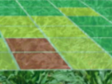
Analysis of high resolution aerial data High-resolution UAV orthoimages and point clouds require methods such as OBIA, machine learning, deep learning, and point-cloud classification.
Reproducible Research Reproducible research is rooted in good scientific practice and transparent, repeatable research work.